As dystopian rhetoric from 'The Hunger Games' seeps into modern slang, a fascinating question emerges: if Panem were based in Britain, which parts of the UK would represent its infamous districts? The phrase 'watching from District 12' is now used on platforms like TikTok to describe observing the lavish lives of the wealthy from a place of deprivation. This has sparked a nationwide debate, with social media users and cultural commentators piecing together a definitive map of a British Panem.
The Opulent Heart and the Wealthy Periphery
The choice for the UK's Capitol requires little deliberation. London stands unchallenged as the opulent, ruling centre, mirroring the extravagance of Panem's capital. With its sky-high property prices—averaging £665,168 compared to the UK's £269,000—and landmarks like the Crown Jewels and The Shard, London embodies the excessive lifestyle of the Capitol's elite.
For District 1, the producer of luxury items, the affluent enclaves of Oxfordshire and The Cotswolds take the crown. This region, home to celebrities from Hugh Grant to royalty, reflects the district's wealth and its residents' noted irritation with intrusive outsiders.

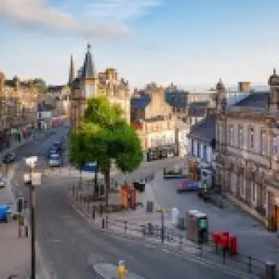
District 2, known for masonry and weaponry, finds its match in Edinburgh. The Scottish capital's wealth and profound stone-building heritage, centred on its medieval castle and historic sandstone quarries like Craighleith, make it a perfect fit.
The Industrial and Agricultural Backbone
The UK's technological hub, District 3, is represented by Milton Keynes. This Bedfordshire city is a powerhouse for electronics, hosting over 2,400 tech firms that generate £3.4 billion annually and even deploying armies of autonomous delivery robots.
When it comes to District 4 and fishing, Aberdeen is the clear choice. Beyond its massive port at Peterhead, the region's diverse rivers and lochs offer rich fishing grounds for salmon, trout, and mackerel, outrivalling suggestions like Cornwall.
Kent logically assumes the role of District 5, the power generator. Its major offshore wind farms, including the pioneering Kentish Flats and the once-world-leading Thanet development, align with the district's hydroelectric function.
For the transport-focused District 6, we look to Belfast. Northern Ireland's capital has a profound shipbuilding legacy, famously constructing the Titanic and fostering an industry that began in the 17th century, making it a worthy hub for Panem's hovercrafts and trains.
The Producers: From Textiles to Livestock
District 7, the lumber district, corresponds to Surrey, where an impressive 31% of the land is covered by trees—the highest percentage in Britain, according to mapping by OVO Energy.
The textile mills of District 8 are best represented by West Yorkshire, particularly Leeds. With the UK's largest textiles sector employing over 10,000 people and supplying major designers like Burberry, it pips Lancashire's cotton history to the post.
Known as the UK's 'bread basket', Norfolk is the ideal District 9. Farmers in East Anglia grow enough grain to produce a staggering 5,774 million loaves annually, perfectly suiting the grain-producing district.
The livestock farms of District 10 have only one true UK equivalent: Wales. With over 10 million sheep—vastly outnumbering its human population—and over 90% of its land used for farming, the country is synonymous with rearing animals.
Lincolnshire embodies the agricultural struggle of District 11. Part of The Fens, it supplies around 20% of England's potatoes, vegetables, and sugar beets, with an agricultural sector worth over £2 billion.
The Deprived and the Forgotten
The coal-mining deprivation of District 12, home to heroine Katniss Everdeen, is mirrored in Newcastle. The phrase 'taking coals to Newcastle' cements its historical identity as a major coal producer, a vital yet less affluent part of the UK's industrial story.

Finally, the secretive, nuclear-focused District 13 is represented by Argyll and Bute in Scotland, specifically The Gare Loch. This is home to HM Naval Base Clyde and the UK's Trident nuclear deterrent submarines, housing the majority of Scotland's estimated 200 nuclear bombs.
So, does your hometown align with a life of Capitol luxury, industrial toil, or agricultural hardship? The map of a British Panem reveals a nation already defined by stark regional contrasts.