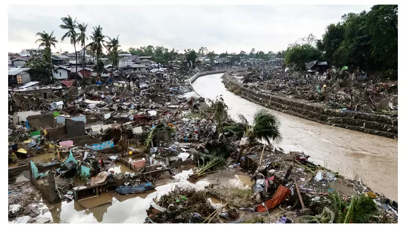
Stunning aerial photographs have laid bare the sheer destructive power of Typhoon Kalmaegi as it tore through the northern Philippines, claiming at least 66 lives and leaving communities in ruins.
Death Toll Rises Amidst Wreckage
The grim tally of fatalities continues to climb as rescue teams battle through treacherous conditions to reach isolated communities. Provincial governor Manuel Mamba confirmed the mounting death count while warning that many residents remain unaccounted for following the typhoon's devastating passage.
A Bird's-Eye View of Catastrophe
From above, the scale of destruction becomes terrifyingly clear. Aerial shots reveal entire landscapes transformed by the storm's fury, with:

- Vast agricultural areas submerged under murky floodwaters
- Roads and bridges severed by raging waters and mudslides
- Communities isolated as infrastructure collapsed
- Farmland and crops completely wiped out
Rescue Operations Race Against Time
Emergency services are working tirelessly to reach those stranded by the catastrophic flooding and multiple landslides. The challenging terrain and continued adverse weather conditions have hampered relief efforts, creating a desperate race against time to locate survivors.
A Region All Too Familiar with Nature's Wrath
The Philippines, situated within the Pacific "Ring of Fire," faces approximately 20 tropical storms annually. Typhoon Kalmaegi serves as another brutal reminder of the nation's vulnerability to extreme weather events, which scientists warn are intensifying due to climate change.
As communities begin the heartbreaking task of rebuilding, the full extent of the damage continues to emerge, painting a picture of a region grappling with profound loss and the monumental challenge of recovery ahead.