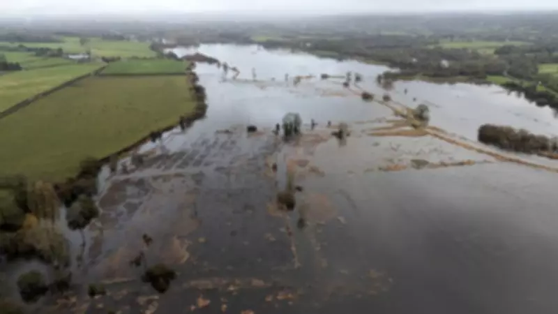
Britain is grappling with a severe flooding crisis as relentless rainfall continues to drench the nation, prompting the Environment Agency to issue over 80 official flood warnings. The situation remains critical, with more than 250 additional flood alerts in place, indicating widespread disruption and potential danger across numerous regions.
Widespread Flooding Threats Across England and Wales
The Environment Agency has activated 82 flood warnings for England, primarily concentrated in the South West and Midlands, where flooding is expected to occur imminently. These warnings are typically issued 30 minutes to two hours before flooding begins, covering risks from river overflows, flash floods caused by heavy rain, and coastal surges during high tides with strong winds.
In addition to the warnings, a staggering 253 flood alerts are currently in force, stretching from North Yorkshire to Cornwall and from the Welsh borders to Norfolk. Natural Resources Wales has contributed another 11 flood alerts for areas across the border, highlighting the cross-border nature of this weather emergency.

Local Emergency Responses and River Level Concerns
Local emergency services are on high alert, with Warwickshire Fire and Rescue Service specifically warning that water levels in the River Dene have risen to a point where flooding is imminent. This localised example underscores the broader national picture of saturated ground and overwhelmed drainage systems struggling to cope with the continuous deluge.
Meteorological Context: A Record-Breaking Wet Start to 2026
The Met Office has confirmed that southwest England and South Wales have experienced rainfall every single day of 2026 so far. Both regions received approximately 50% more precipitation than usual during January, setting the stage for the current crisis. Meanwhile, the South East recorded nearly one-third of its average February rainfall in just the first three days of the month.
Cornwall endured its wettest January on record, while other parts of the British Isles approached similar extremes. Exeter Airport, among other locations, has documented rainfall on every day this year, contributing to the persistently gloomy conditions.
Atmospheric Patterns Driving the Unrelenting Rain
Meteorologists attribute this sustained wet weather to specific atmospheric conditions. The jet stream, a fast-moving ribbon of air high in the atmosphere that typically steers weather systems from west to east, has shifted southward and developed a wavy pattern. This configuration has created blocked weather patterns, with Scandinavia experiencing settled high pressure while the UK remains trapped under successive low-pressure systems.
A dominant southeasterly airflow has been pushing bands of showery rain northwards across the country, with southern parts of the UK particularly affected by the jet stream's southerly position. Interestingly, northwest Scotland has enjoyed relatively drier and brighter conditions amidst this national weather crisis.
Forecast: More Rain Ahead with Potential Cold Snap
The immediate forecast offers little relief. Saturday is expected to bring more wet weather to large areas of the country, including blustery showers in the South West and heavy downpours in South Wales. Sunday may provide a brief respite with some sunshine mixed with showers, but wet and windy conditions are predicted to return at the start of next week.
Meteorologists warn that the unsettled pattern could persist well into next month, with no significant improvement expected until the weather pattern "unblocks." There is also a risk of colder conditions developing towards the end of next week, potentially bringing wintry hazards to some regions.
International Context and Expert Commentary
The UK is not alone in experiencing exceptional rainfall. A succession of storms has battered Iberia, with Storm Marta recently affecting Portugal, Spain, and Gibraltar following a very wet January that saw some areas receive three times their normal rainfall.
Dan Stroud, an operational meteorologist with the Met Office, stated bluntly: "Unfortunately, there's no end in sight." His colleague Alex Deakin confirmed that Friday continued the trend of soggy conditions across much of the country, with cold winds feeding moisture into northeast England and eastern Scotland.

Mr. Stroud explained the meteorological stagnation: "We've got a big area of high pressure way out to the far north and east of the country, and that's stopping areas of low pressure from moving through. Until that area of high pressure shifts out of the way, we're not really going to see much of a change in the forecast."
The combination of this blocking high pressure to the northeast and the southerly positioned jet stream has created perfect conditions for sustained rainfall across the UK, while simultaneously directing exceptional wet weather toward Spain and Portugal.