The Met Office has issued a fresh yellow weather warning for heavy rain across extensive areas of southwest England and South Wales, as hundreds of flood alerts remain in place across the United Kingdom. This new alert comes amid a period of exceptionally wet weather that has persisted since the beginning of the year.
Details of the Latest Weather Warning
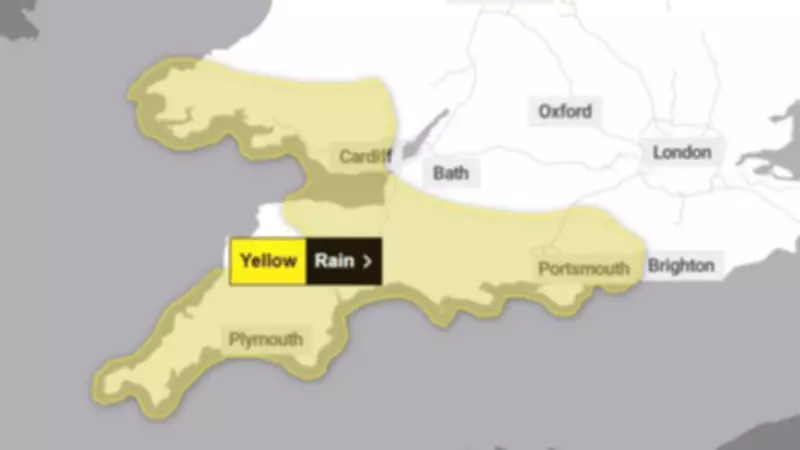
The newly announced yellow warning is scheduled to be in effect from 12pm on Monday through to midnight, covering a broad swathe of the country. In southwest England, the warning spans from Cornwall in the west to Portsmouth in the east, encompassing major urban centres and coastal towns.
Affected locations include Truro, Plymouth, Torquay, Exeter, and Taunton. Further east, areas such as Weymouth, Wareham, Southampton, Salisbury, and Chichester are also within the warning zone. Across the Bristol Channel in South Wales, the warning covers Cardiff, Swansea, Newport, and extends to St David's.

Flood Alerts and Warnings Across the Nation
Simultaneously, the Environment Agency is maintaining significant flood management measures across England. According to their latest updates, there are currently 88 active flood warnings in place, predominantly concentrated in southwest England and both the East and West Midlands regions.
Additionally, the agency has issued 223 flood alerts nationwide. It is important to understand the distinction between these classifications: a flood warning indicates that flooding is expected to occur, requiring immediate action from those in affected areas, while a flood alert signifies that flooding is possible and that residents should remain prepared.
Context of Persistent Wet Weather
This latest warning follows what has been an exceptionally wet start to 2026 across many parts of the United Kingdom. The Met Office confirmed on Thursday that rain has fallen every single day of the year so far in both southwest England and South Wales.
Both regions have experienced rainfall volumes approximately 50% higher than their seasonal averages. This follows a January that was significantly wetter than normal, with the same 50% above-average rainfall recorded across these areas.
Broader Weather Patterns and Records
The current weather situation forms part of a wider pattern of unusual meteorological conditions being observed across the UK. Several notable records and statistics highlight the extent of this persistent wet period.
For instance, Aberdeen has recorded zero hours of sunshine since 21 January, marking the longest sunless period in the city since 1957. Similarly, Sheffield has experienced no sunshine whatsoever during the month of February to date.
In Northern Ireland, Katesbridge recorded its wettest February day on record on 5 February, with 67.2mm of rainfall measured within a 24-hour period. This substantially exceeded the previous February site record of 42.2mm set back in 1985.
Nationally, rainfall has fallen every day for the last 37 consecutive days, meaning it has rained on every single day of 2026 so far. Several monitoring sites across the country haven't recorded a completely dry day since 30 December, which would mean Sunday's rainfall would represent the 40th consecutive day of precipitation.
Exeter Airport provides another striking example, having not experienced a single dry day since 31 December. While the UK as a whole has recorded below-average sunshine hours for the winter period to date, rainfall distribution has been quite varied geographically. Eastern Scotland has been particularly wet, while Western Scotland has remained relatively dry in comparison.
Residents in affected areas are advised to stay informed through official weather forecasts and flood warnings, prepare appropriate precautions, and follow guidance from local authorities and emergency services as this developing weather situation continues to unfold.