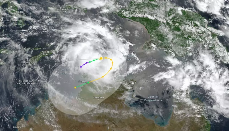
A developing tropical cyclone is charting a course towards northern Australia, threatening to make meteorological history. Tropical Cyclone Fina could equal the record for the earliest cyclone to make landfall in Australia if it crosses the coast this Friday.
Storm Track and Potential Records
As of Wednesday afternoon, the Category One system was positioned approximately 370 kilometres north-east of Darwin. The Bureau of Meteorology anticipates Fina will intensify to a Category Two cyclone before turning south on Thursday. Its projected path suggests a potential impact on the Northern Territory coast on Friday or Saturday.
Senior meteorologist Jonathan How confirmed the significance of this timing. The earliest cyclone to make landfall in Australia was Cyclone Ines, which crossed the Kimberley coast on 21 November 1973. For the Northern Territory specifically, the earliest landfall was recorded by Cyclone Alessia on 27 November 2013.

"Based on Fina’s track map it could also cross the coast on the 21st or 22nd of November, so that could equal the record for earliest landfall," How stated. This would also set a new record as the earliest cyclone to ever cross the NT coast.
Climate Change and Cyclone Intensity
Professor Steve Turton, an adjunct professor at Central Queensland University, highlighted the role of a warming climate in shaping such weather events. While fewer tropical cyclones are anticipated overall, scientific assessments, including the national climate risk assessment, predict a higher proportion of severe Category Four and Five cyclones.
"We do know that with climate change that we’re expecting the intensity of these storms to increase. We’re expecting them to intensify more rapidly. We’re already seeing those patterns," Turton explained.
He pointed to above-average sea surface temperatures in the Timor Sea, which are well above the 26.5°C threshold required for cyclone formation, as a key factor. Furthermore, Fina's small size makes it particularly unpredictable. "Because it’s small, it’s likely to spin up quicker. But it can also weaken quicker... these small cyclones can sometimes catch you unawares and suddenly they intensify very rapidly," he warned.
Local Impact and Historical Context
The Bureau's latest track map indicates that Darwin could be affected by the approaching system. The most recent significant cyclone to impact the city was Cyclone Marcus in 2018. That event, a Category Two system, brought wind gusts of 130km/h, felling trees and causing widespread power outages.
This early-season development is unusual. Although Australia's official cyclone season begins on 1 November, the first system to cross land typically does not occur until mid to late December on average. The imminent arrival of Cyclone Fina underscores a potentially volatile start to the season, with experts linking its rapid development to broader environmental changes.