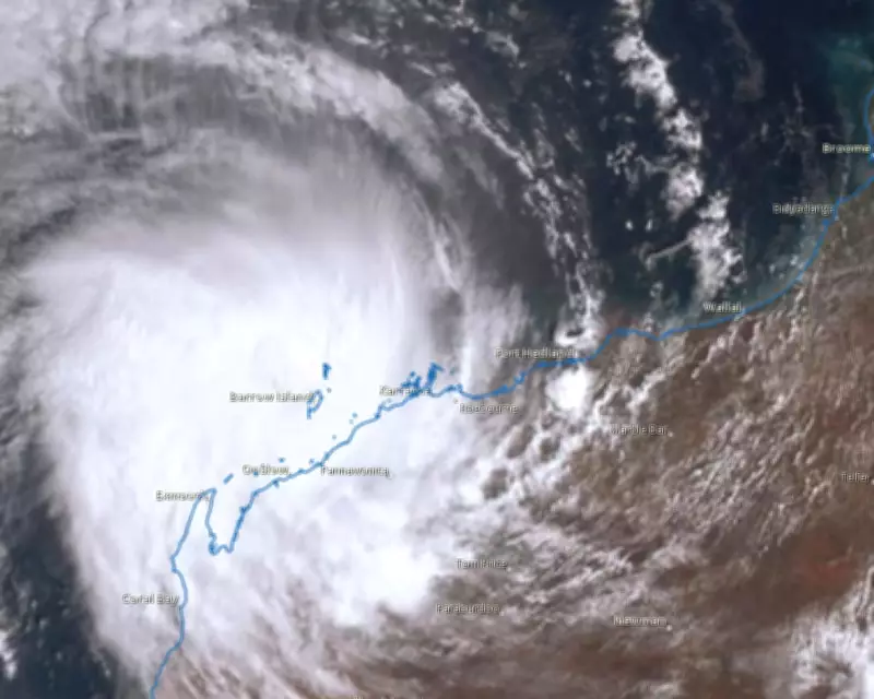
The Bureau of Meteorology has issued urgent cyclone warnings as Severe Tropical Cyclone Mitchell intensifies to a dangerous category 3 storm, threatening communities along Western Australia's north-west coastline. Satellite imagery captured at 9.10am AWST on Sunday shows the powerful weather system gathering strength as it approaches land.
Imminent Landfall with Destructive Winds
Senior meteorologist Miriam Bradbury confirmed that Mitchell was maintaining category 3 intensity while moving south-west parallel to the Pilbara coast. The cyclone was positioned approximately 30 kilometres offshore west of Karratha on Sunday morning, generating sustained winds of 120km/h near its centre with gusts reaching 165km/h.
"The expectation is that it will maintain its category 3 intensity as it moves south-west today, parallel to the Pilbara coast," Bradbury stated, noting the system could potentially intensify further or slow slightly while remaining over water.

Emergency Warnings Activated
Emergency services have declared a warning zone stretching from Karratha to Cape Cuvier, just north of Carnarvon, with the most severe conditions anticipated between Exmouth and Onslow. Residents in affected areas have been urged to seek immediate shelter indoors as the cyclone approaches.
EmergencyWA has issued cyclone emergency warnings covering communities from Whim Creek to Onslow, with forecasters warning that very destructive wind gusts could reach up to 195km/h as Mitchell's core approaches the coastline. Early wind measurements recorded gusts of 169km/h at Legendre Island on Saturday evening and 148km/h at Barrow Island on Sunday morning.
Multiple Hazards Expected
The approaching cyclone brings multiple threats beyond high winds. Widespread moderate to heavy rainfall has already begun affecting the region, with Karratha recording 67mm of rain since midnight. Meteorologists warn of potential flash flooding across the west Pilbara coast, accompanied by abnormally high tides that could extend to the Gascoyne region on Monday.
"The rain comes in, our rivers start rising, and we're likely to see impacts for roads, access routes, impacts for communities through those areas too," Bradbury explained, highlighting the compounding dangers facing coastal communities.
Broader Weather Impacts
Moisture streaming from Tropical Cyclone Mitchell is contributing to severe thunderstorm risks across central and south-eastern states, including parts of New South Wales, Victoria, Tasmania and inland South Australia. This atmospheric moisture could bring significant rainfall to drought-affected regions, though it also increases flood risks.
"That's significant, because storms could bring rain to some very dry parts of the country," Bradbury noted, acknowledging both the potential benefits and hazards of the weather pattern.
Cyclone Season Context
Mitchell represents the fifth tropical cyclone to make landfall this season, following tropical cyclones Fina, Hayley, Koji and Luana. Australia typically experiences about ten tropical cyclones annually during cyclone season, with three to four systems typically crossing the coast.
Climate scientists note that while fewer tropical cyclones are anticipated in a warming climate, the proportion of severe events like Mitchell could increase according to national climate risk assessments. This trend highlights growing concerns about extreme weather events in vulnerable regions.
Residents across the warning zone remain on high alert as emergency services monitor the cyclone's progress, with landfall expected between Exmouth and Onslow late Sunday evening or early Monday morning.