Beast from the East Set for February Return with Heavy Snowfall
Britain is bracing for a dramatic return of the infamous 'Beast from the East' as weather models predict a severe three-day blizzard that could blanket the country in up to 26 inches of snow during a February cold snap. According to the latest forecasts, this significant weather event is poised to strike from February 8, bringing widespread disruption and wintry conditions across the UK.
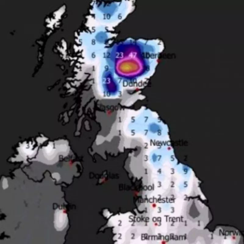
Weather Maps Reveal Snow System Formation
The GFS weather model indicates that a substantial snow system will develop to the east of Britain on February 8. Initially, northern England and Scotland may experience lighter snowfall, but meteorologists warn that this system could merge with another approaching from the south, potentially creating a perfect storm that engulfs the entire nation. The Met Office has echoed these concerns, noting that weather fronts from the north-east and south-west are likely to collide in early February.
A forecaster from the weather service explained: "Weather systems from the Atlantic will continue to attempt to push in from the west, but tending to stall in the vicinity of the UK as they encounter high pressure to the north and north-east. As a result, further spells of rain or showers as well as strong winds are expected at times." The forecast concludes with a stark warning: "Where fronts from the south-west do reach the cold air towards the north-east, there is the risk of some snow, most likely across hills, but perhaps extending to lower areas at times."

Detailed Three-Day Snow Forecast
February 8: Weather charts point to intense snowfall sweeping across southern England around midnight, while a broad swathe of deep purple on the maps signals snow spreading into the Midlands, Wales, northern England, and Scotland. Major urban centres including Birmingham, Manchester, Newcastle, and Edinburgh appear firmly in the firing line, with residents advised to prepare for significant accumulations.
February 9: By midday, forecast models show snow pushing into Northern Ireland, with Belfast among the first areas to be affected. The most severe conditions, however, are expected to take hold across north-eastern England, while the north-west also faces sustained flurries. By nightfall, Northern Ireland is projected to bear the heaviest snowfall, as southern, central, and north-eastern Scotland continue to see persistent accumulations throughout the day.
February 10: By 3am, forecast maps show settled snow stretching across parts of southern England and the Midlands, and covering almost the whole of Wales, Northern Ireland, northern England, and Scotland. Depth projections indicate that the Scottish Highlands could face the most dramatic accumulations, with totals potentially reaching 65cm (26 inches). Meanwhile, the North Pennines might witness 16cm (six inches), Northern Ireland could see 8cm (three inches), and North Wales approximately 4cm (1.5 inches).
Potential Impacts and Preparations
This impending weather event has raised alarms among transport authorities and emergency services, as such heavy snowfall could lead to:
- Widespread travel disruptions across road, rail, and air networks
- Potential school and business closures in affected regions
- Increased strain on energy supplies and heating systems
- Heightened risks for vulnerable populations during the cold snap
Residents across the UK are being urged to monitor weather updates closely and prepare for possible power outages and difficult travel conditions. The Met Office is expected to issue further warnings as the event approaches, with particular attention to areas most likely to experience the heaviest snowfall.
This forecast comes as a reminder of the 2018 Beast from the East that brought similar conditions, causing widespread chaos across the country. While weather patterns can change, current models suggest Britain should prepare for a significant winter weather event that could test infrastructure and resilience across multiple regions.