UK Flood Warnings Surge as Relentless Rain Continues to Batter Nation
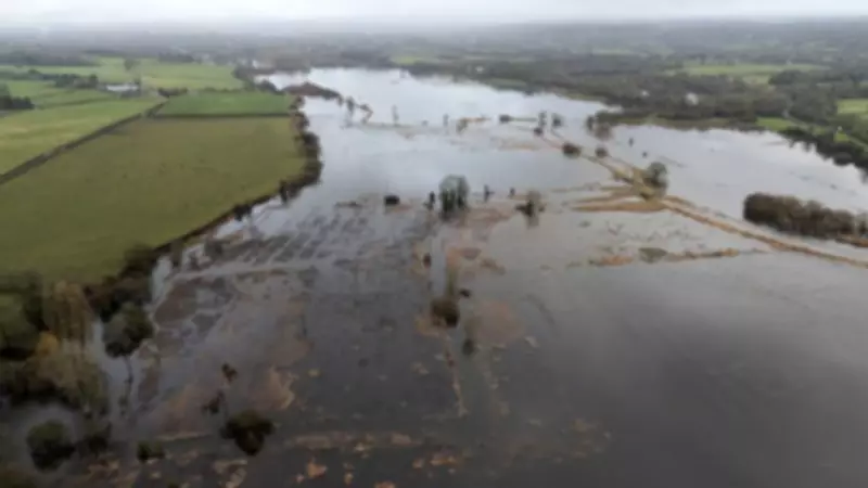
Dozens of flood warnings have been issued across the United Kingdom as more heavy downpours are expected to hit large parts of the country this weekend. The Environment Agency has confirmed that 78 flood warnings are currently in place for England, primarily concentrated in the South West and Midlands regions, indicating that flooding is anticipated imminently.
Widespread Flood Alerts Across the Nation
In addition to the flood warnings, more than 249 flood alerts have been activated across England, stretching from North Yorkshire to Cornwall and from the Welsh borders to Norfolk. These alerts signify that flooding is possible and residents should remain vigilant. Natural Resources Wales has implemented another 11 flood alerts, while Scotland is dealing with one flood warning and five alerts.
The situation has become particularly critical in some areas. Warwickshire Fire and Rescue Service has issued an urgent warning that water levels in the River Dene have risen to a point where flooding is imminent. According to the Environment Agency, flood warnings are typically issued between 30 minutes and two hours before flooding occurs, triggered by factors such as river overflow, heavy rainfall causing flash floods, and high tides combined with strong coastal winds.

Continued Wet Weather Forecast
Further wet weather is predicted for Saturday, with blustery showers expected in the South West and heavy downpours forecast for South Wales. Sunday may offer a brief respite with a mix of showers and sunshine, but wet and windy conditions are set to return at the start of next week, prolonging the unsettled pattern.
Meteorological data reveals that the South West and South Wales have experienced rainfall every single day of 2026 so far. Both regions have recorded approximately 50% more rainfall than the usual average for January. Meanwhile, the South East received nearly one-third of its typical February rainfall in just the first three days of the month, highlighting the intensity of the current weather systems.
Unprecedented Rainfall Records
The persistent rain has led to several remarkable weather records. Cornwall experienced its wettest January on record, while other parts of the British Isles followed closely behind. Exeter Airport has not recorded a single dry day since the beginning of the year, and Aberdeen went nearly two weeks without any sunshine, marking its longest sunless period since 1957.
In the first five days of February alone, Aberdeen received more than its usual monthly rainfall. The Isle of Wight is currently at 97% of its average February rainfall, significantly higher than the expected 18% for this time of the month. Katesbridge recorded its wettest February day on record with 67.2mm of rainfall in 24 hours, surpassing the previous record set in 1985.
Meteorological Explanation for the Persistent Rain
Broadcast meteorologist Kirsty McCabe explains that the culprit behind this relentless weather is the jet stream, a fast-moving ribbon of air high in the atmosphere that steers low-pressure systems. Currently, the jet stream is meandering southward, creating blocked weather patterns. While Scandinavia enjoys settled conditions under high pressure, the UK remains trapped under successive low-pressure systems, resulting in continuous bands of showery rain moving northwards across the country.
This southerly position of the jet stream has particularly affected southern parts of the UK, while northwest Scotland has experienced relatively drier and brighter conditions. Unfortunately, meteorologists predict that this unsettled outlook will continue into next month, with no significant improvement expected until the weather pattern shifts.
Official Warnings and Future Outlook
Dan Stroud, an operational meteorologist with the Met Office, stated emphatically that "there's no end in sight" to the current rainfall. His colleague Alex Deakin confirmed that the trend persisted on Friday, describing it as "a very soggy day across a good chunk of the country" with cold winds feeding moisture into northeast England and eastern Scotland.

Mr Stroud attributed the sustained bleak conditions to a large area of high pressure located far to the north and east of the country, which is preventing low-pressure systems from moving through. Until this high-pressure system shifts, the forecast remains unchanged. The UK is not alone in facing exceptional rainfall; successive storms have battered Iberia, with Storm Marta recently affecting Portugal, Spain, and Gibraltar following a very wet January that saw some areas receive three times their normal rainfall.
As the nation braces for more rain, authorities urge residents in affected areas to stay informed through official channels and take necessary precautions to protect property and ensure personal safety.