UK Braces for Extended Period of Heavy Rainfall
The United Kingdom is preparing for up to ten additional days of persistent rain, according to the latest forecasts from the Met Office. This continuation of wet weather follows a record-breaking spell that has already saturated many regions, with no immediate sign of relief in sight.
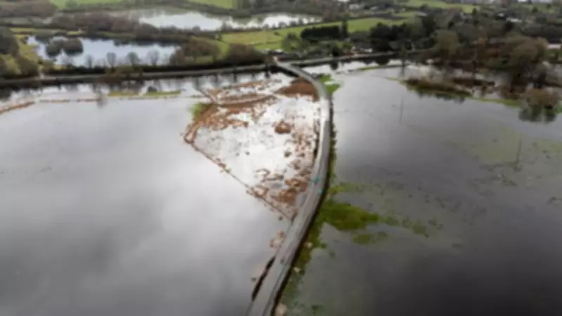
Flood Warnings Escalate Across the Nation
As of Monday afternoon, the Environment Agency had issued 107 flood warnings across England, indicating that flooding is expected in these areas. The Scottish Environment Protection Agency added two more warnings for Scotland, while Wales recorded five flood alerts. In total, England faced 197 flood alerts, signaling possible flooding in vulnerable locations.
Andrew Hitchings, Flood Duty Manager at the Environment Agency, emphasised the seriousness of the situation. "With another band of rain on its way, we need the public to remain vigilant to the risk of flooding," he stated. "Our teams will continue to do all they can to support local people, with pumps, temporary barriers and by clearing waterways to ensure flood water can drain away."

Record-Breaking Rainfall Statistics
Meteorologists have highlighted several extraordinary weather statistics that underscore the severity of this winter's conditions:
- Rain has fallen every day for the last 37 days across the UK, with no entirely dry days since 30 December in several locations.
- Reading experienced 25 consecutive days of rain, the longest unbroken spell recorded since the University of Reading began keeping records in 1908.
- Katesbridge recorded its wettest February day on record with 67.2mm of rainfall in 24 hours on 5 February.
- Exeter Airport has not had a single dry day since 31 December.
- Southwest England and South Wales have seen 50% more rainfall than usual this year, with both areas experiencing far wetter than average January conditions.
Meteorological Causes Behind the Persistent Rain
Simon Partridge, Senior Operational Meteorologist at the Met Office, explained the atmospheric conditions driving this extended period of unsettled weather. "The weather is set to remain unsettled throughout the remainder of the week with further spells of wet and windy weather for many areas of the UK," he said. "There is currently no sign of any prolonged dry weather for the next seven to 10 days."
Broadcast meteorologist Kirsty McCabe identified the jet stream as the primary culprit. This fast-moving ribbon of air high in the atmosphere has been meandering southward rather than flowing directly west to east, creating blocked weather patterns that have trapped the UK under successive low-pressure systems.
Regional Impacts and Weather Warnings
A yellow weather warning remains in effect for large parts of southern England and South Wales, valid from noon on Monday until midnight. The Met Office predicts 10-15mm of rain across most affected areas, with 20-30mm possible in locations exposed to strong southeasterly winds.
Specific regions under warning include:
- Hampshire, the Isle of Wight, Portsmouth, Southampton and West Sussex
- Cornwall, Devon and Dorset in southwest England
- Cardiff, Swansea and Newport in Wales
The warning forecasts potential flooding on roads leading to longer journey times, possible impacts on bus and train services, and a chance of flooding for some homes and businesses. There is also a risk of interruptions to power supplies and other essential services.
Looking Ahead: Continued Unsettled Conditions
Met Office meteorologist Tom Morgan confirmed that Monday's weather would bring "much the same, with further spells of rain." The most persistent rainfall is expected in the far northeast of Scotland, particularly Orkney and Shetland, while Wales and the South West will experience outbreaks of fairly heavy rain that could lead to additional flooding.
Brisk southeasterly winds are predicted to create large waves along the south coast, adding to the challenging conditions. While the Midlands and parts of the South East may see some brighter periods, the overall outlook remains unsettled well into next month.

McCabe noted that until the weather pattern "unblocks," more rain is inevitable, with conditions potentially turning colder toward the end of next week and bringing a risk of wintry hazards. The UK is not alone in experiencing exceptional rainfall, with Iberia also facing successive storms that have delivered three times the normal January rainfall in some areas.