The United Kingdom is bracing for a major bout of winter weather as the year's first named storm, Storm Goretti, prepares to strike. The Met Office has issued a series of severe weather warnings for snow, ice, and wind, following the coldest night of the winter so far.
Widespread Warnings and Disruption Forecast
Meteorologists warn that Storm Goretti, named by the French service Météo-France, will bring significant disruption from Thursday 8th January into Friday 9th January 2026. The southern UK is expected to bear the brunt, but impacts will be felt nationwide.
Sky News meteorologist Dr Christopher England explained that while the exact track remains uncertain, the most likely scenario involves heavy rain spreading from the southwest on Thursday, turning to snow from Wales across to East Anglia. He warned of "significant falls" of snow and "severe gales around southern coasts".

The Met Office snow warning for Thursday and Friday indicates that 5-10 cm of snow may settle widely, with up to 20 cm possible in some locations, particularly over higher ground.
Cold Snap Intensifies Ahead of Storm
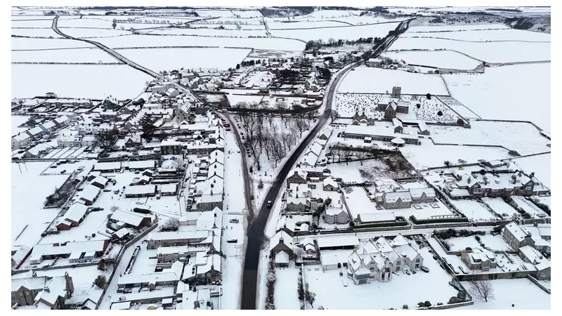
The storm threat follows an intense cold snap, with Monday night confirmed as the coldest of the winter. The Met Office recorded a low of -12.5C (9.5F) in Marham, Norfolk. Dalwhinnie in the Scottish Highlands saw temperatures drop to -11.2C (11.84F), while Londoners woke to -5C (23F) at 5am on Tuesday.
In response to the prolonged freeze, the UK Health Security Agency (UKHSA) has extended its amber cold health alerts across England until midday on Sunday. Authorities in Aberdeenshire declared a major incident, anticipating a prolonged period of severe impacts.
The council warned residents of multiple hazards, including:
- Significant travel delays and potential strandings.
- Disruptions to rail and air travel.
- Rural communities being cut off.
- An increased risk of injuries from slips and falls on ice.
- The potential for power cuts affecting other services like mobile networks.
Met Office Issues Multi-Day Alert
A cascade of weather warnings is now in force. For Wednesday 7th January, three yellow warnings cover:
- Ice across Northern Ireland.
- Snow and ice for northern mainland Scotland, parts of the Outer Hebrides, and Orkney.
- Ice for much of England and Wales, excluding the southwest and western coasts.
On Thursday, two new yellow warnings come into effect: one for wind in southwest England and another for snow across much of Wales, the Midlands, Bath, Bristol, and Oxford. This snow warning remains until midday on Friday.
The disruption has already begun, with hundreds of schools in Shetland, Orkney, and Aberdeenshire closed on Tuesday under amber snow warnings. National Rail reported ongoing disruption to train services in northern Scotland.
As Storm Goretti approaches, the public is urged to stay updated with the latest forecasts and travel advice, and to check on vulnerable neighbours during this period of severe winter weather.