UK Flood Crisis: Over 100 Warnings Issued as Heavy Rain Continues
The United Kingdom is grappling with a significant flooding crisis as meteorological authorities issue more than 100 flood warnings across the nation. This alarming situation comes amid forecasts of further heavy rainfall, exacerbating concerns for communities already affected by relentless wet weather.
Met Office Issues Widespread Flood Warnings
The Met Office has escalated its flood warnings to 114 across England, a substantial increase from the previous 89 alerts. In Scotland, the Scottish Environment Protection Agency (SEPA) has issued an additional six warnings, highlighting the widespread nature of the threat. A yellow weather warning for heavy rain remains in effect for large swathes of southern England and South Wales, active from midday on Monday until midnight.
Forecasters predict rainfall accumulations of up to 30mm in some exposed locations, with 10-15mm expected more widely. The Met Office warns that bands of rain and heavy showers will move eastwards across southern parts of England and Wales during Monday afternoon and evening, driven by strong south to southeasterly winds.

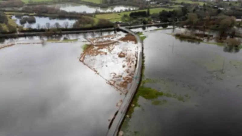
Affected Regions and Transport Disruptions
The flood warnings span numerous counties and cities, including Hampshire, the Isle of Wight, Portsmouth, Southampton, and West Sussex. In southwest England, areas such as Cornwall, Devon, and Dorset are on high alert, while in Wales, Cardiff, Swansea, and Newport are among the affected zones.
Transport networks are expected to face severe disruptions. The Met Office forecasts spray and flooding on roads, likely extending journey times significantly. Bus and train services may be impacted, and there is a possibility of flooding in some homes and businesses. Additionally, there is a chance of interruptions to power supplies and other essential services.
Environment Agency's Role and Ongoing Concerns
Meanwhile, the Environment Agency has 89 flood warnings in place, primarily across southwest England and the East and West Midlands. The agency also maintains 218 flood alerts nationwide. It is crucial to understand the distinction between these terms: a flood warning indicates that flooding is expected, whereas a flood alert signifies that flooding is possible.
Sarah Cook, flood duty manager at the Environment Agency, expressed sympathy for those impacted by Storm Chandra, noting that some homes and businesses have already been flooded. She warned of significant ongoing groundwater flooding in parts of Dorset and Wiltshire, with minor impacts probable in Hampshire for the next five days and West Sussex from Saturday.
"Our teams are on the ground working to reduce the impact of flooding and support affected communities," Cook stated. "We urge people not to drive through flood water—it is often deeper than it looks, and just 30cm of flowing water can float a car."
Record-Breaking Rainfall and Gloomy Weather Patterns
The current flooding crisis follows an exceptionally wet period. The Met Office reported that rain has fallen every day of 2026 so far in southwest England and South Wales, with both regions experiencing 50% more rainfall than usual. January was far wetter than average, and February continues this trend.
Notable weather facts underscore the severity of the situation:

- Aberdeen endured zero hours of sunshine from 21 January, marking its longest sunless period since 1957.
- Sheffield has recorded zero hours of sunshine so far this month.
- Katesbridge experienced its wettest February day on record on 5 February, with 67.2mm of rain in 24 hours.
- The UK has seen rain every day for the last 37 days, meaning every day of the year so far.
- Several locations across the UK have not had a completely dry day since 30 December.
- Exeter Airport has not recorded a dry day since 31 December.
- Overall, the UK has had below-average sunshine hours for winter, with rainfall varying significantly by region.
Unsettled Forecast and Meteorological Explanations
Meteorologists attribute the persistent wet weather to a meandering jet stream, which has led to blocked weather patterns. Instead of flowing west to east, the jet stream has dipped southwards, resulting in low-pressure systems bringing continuous rain to the UK. Scandinavia enjoys settled conditions under high pressure, while the UK remains stuck with successive lows.
This pattern has caused exceptional rainfall totals, particularly in southern parts of the country. For instance, Cornwall had its wettest January on record, and the Isle of Wight has already reached 97% of its typical February rainfall in just the first few days. In contrast, northwest Scotland has experienced drier and brighter conditions.
The forecast remains unsettled, with no immediate improvement in sight. Drier and brighter spells may occur between rainbands, but the overall outlook suggests continued wet weather into next month. There is also a potential for colder conditions and wintry hazards towards the end of next week.
This flooding crisis mirrors similar challenges in Europe, such as in Iberia, where a succession of storms, including Storm Marta, has battered Portugal, Spain, and Gibraltar following a very wet January.