Severe Tropical Cyclone Narelle is barrelling toward the far north Queensland coast, with the Bureau of Meteorology forecasting it will make landfall as a monstrous category 5 storm at 7am on Friday. Destructive wind gusts of up to 315km/h are expected, leading to widespread evacuations, school closures, and emergency preparations in vulnerable communities.
Rapid Intensification and Landfall Timeline
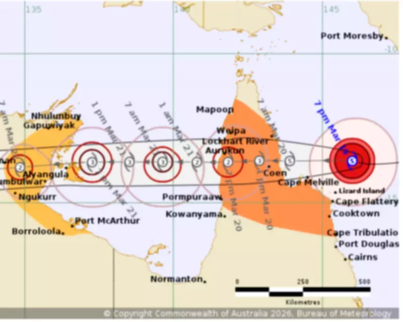
The cyclone has intensified rapidly over the past 48 hours, reaching category 5 status on Thursday morning. It is currently moving west at approximately 20km/h, positioned about 355km east of the small town of Coen, which has a population of around 330 residents. The Bureau of Meteorology has revised its forecast, indicating landfall will occur three hours earlier than initially predicted.
Historical Context and Regional Impact
If Narelle crosses the coast as a category 5 system, it will mark the first such event in the Cape York region since Cyclone Mahina in 1899, which resulted in over 300 fatalities. Premier David Crisafulli noted that this would be only the fourth category 5 cyclone to hit the Queensland coastline in the last half-century, underscoring the severity of the threat.

Emergency measures are in full swing, with more than 100 personnel deployed to the north. Police are conducting door-to-door checks to ensure residents are prepared, while shipping containers of supplies have arrived and emergency generators are on standby. Tourists have been evacuated on the last available flights, and schools in the warning zone, affecting about 780 students, have been closed.
Warnings and Expected Damage
Premier Crisafulli has issued stark warnings, emphasizing the risks of strong winds, heavy rainfall, storm surges, and flash flooding. "I can't sugar-coat this. The damage will be widespread," he stated, urging residents to take the situation seriously. The cyclone is fueled by warmer-than-average ocean temperatures in the Coral Sea, which have contributed to its rapid intensification.
Forecaster Angus Hines from the Bureau of Meteorology highlighted that Narelle could bring daily rainfall totals of 150mm to 300mm in the Cape York region, with localized amounts reaching up to 450mm. "That is enough to cause flash flooding and cause river levels to climb so we should expect flooding as the rain works its way through the river systems," Hines explained.
Broader Weather Patterns and Climate Factors
After making landfall, Narelle is projected to move over the Gulf of Carpentaria and cross the Top End by Saturday evening as a category 3 system, potentially affecting areas like Katherine and Daly River that have recently experienced devastating floods. Climate scientist Andrew Watkins pointed out that the Coral Sea has recorded record-high sea surface temperatures, providing ideal conditions for cyclone formation and intensification.
This event follows other severe cyclones in recent years, such as Ilsa in 2023 and Marcia in 2015, highlighting ongoing challenges posed by extreme weather in Australia. Authorities continue to monitor the situation closely, with updates expected as the storm progresses.