A London statistician has embarked on an extraordinary decade-long mission to digitally map Britain's waterways entirely on foot, becoming one of Google's most prolific contributors worldwide.
The Man Behind the Camera
Dr Uy Hoang, 51, from London began his remarkable project in 2015 after becoming frustrated that he couldn't view his local towpath on Google Maps. What started as a simple idea has evolved into a massive undertaking that has seen him cover approximately 75% of Britain's canal network over ten years.
The University of Oxford statistician told reporters: "Everybody uses Google Maps to try to plan journeys, and I was thinking 'why isn't this stuff on Google Maps?' It's obvious you can go down there and photograph it to help people out with their planning."

An Epic Journey in Numbers
Dr Hoang's achievement is staggering in scale. He has taken approximately 300,000 photographs during his travels and walked an estimated 1,600 miles along the nation's rivers and canals. His dedication has made him Britain's most prolific Google Street View contributor and the ninth most active globally.
He typically spends eight to ten hours daily walking with his £1,000 Insta360 camera, capturing paths too narrow for Google's Street View vehicles. "Why have a bad map? It's like having no map," he explained. "If you have a bad map, you're led down wrong places, you do incorrect planning, you waste more time."
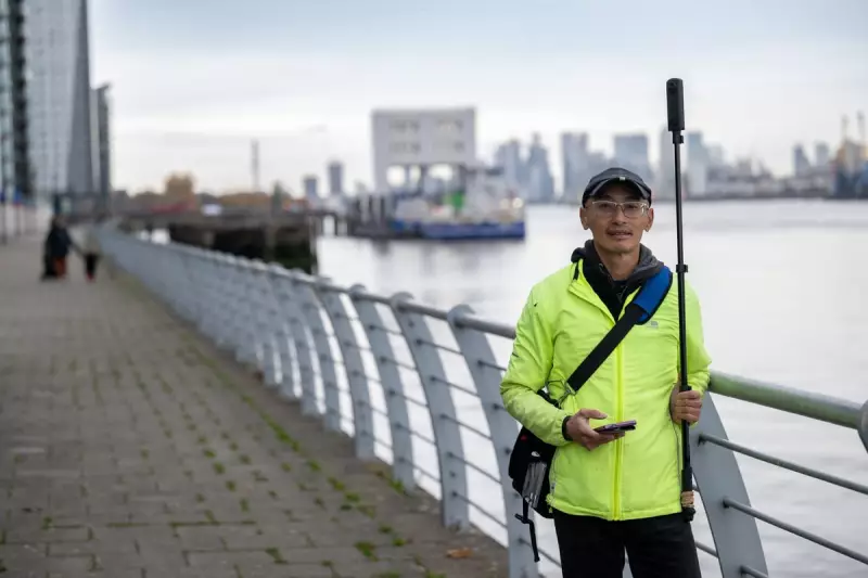
Perfecting the Technique
Dr Hoang experimented with various methods before settling on his current approach. He initially tried mounting cameras on tripods and bicycles but discovered that walking while holding the camera on a pole above his head produced the best results.
"I walk everywhere because it allows you to access all the spaces that you can't with a bicycle," he said. His lightweight equipment strategy helps manage fatigue during all-day photoshoots. "I use a lightweight monopod and keep it close to my body to minimise the amount of weight I am carrying away from my core muscles."
The dedicated mapper can only work during summer months when lighting conditions are optimal for the longest duration. He plans routes carefully, typically starting near hotels or public transport and ending where he can easily return home.
Dangers and Discoveries
His excursions aren't without risk. Fast-flowing water combined with narrow paths presents genuine danger, and he remains mindful of potential security threats when carrying expensive equipment in isolated areas.
"It really dawned on me when I was at the Bristol Basin," Dr Hoang recalled. "At low tide, the River Avon is about 20ft below the dock, and underneath is just mud. I was standing at the side and nobody was there because it was six in the morning. I thought 'if I slip, there's no way anybody's going to find me.'"
He has also encountered unexpected hazards like large potholes on canal paths and has fallen into several during his travels. Beyond physical dangers, Dr Hoang has witnessed significant environmental issues, noting substantial pollution in Britain's waterways.
"You see a lot of wet wipes, this sort of gunky, homogenised stuff," he described. "You see mattresses, Lime bikes, shopping trolleys, fridges, motorbikes, all sorts of weird stuff."
Unexpected Benefits and Global Importance
His work has proven valuable beyond helping pedestrians and cyclists plan their routes. Flood risk modellers have contacted him to say they use his photographs to help plan flood mitigation measures.
Dr Hoang emphasises the broader importance of his project, particularly given environmental pressures. "There are so many pressures on our rivers - not least pollution, but also climate change. It's really important that we start to map them now before change becomes irrevocable."
He points out that many of the world's great rivers, including the Nile, Mekong, and Mississippi, remain largely unmapped on digital platforms. "Huge chunks, we don't have any mapping. It's really important we start thinking about how we can get these rivers mapped."

After ten years and hundreds of thousands of photographs, Dr Hoang continues his mission to ensure Britain's waterways are properly documented for future generations, proving that sometimes the most advanced digital mapping requires the simplest human approach: putting one foot in front of the other.