Northern Territory Grapples with Historic Flooding Crisis
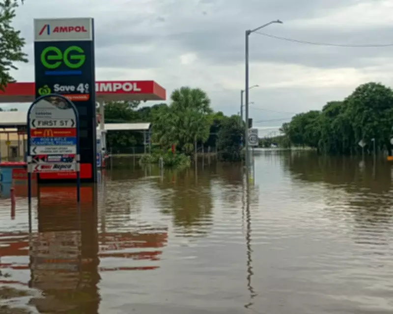
The Northern Territory is confronting its most severe flooding event in decades, with multiple communities evacuated and urgent public health warnings issued. The NT health department has activated boil water alerts for several areas, including Katherine, Wugularr (Beswick), Tindal, Palumpa, and Nauiyu (Daly River), as floodwaters inundate infrastructure and contaminate water supplies.
Record-Breaking Rainfall Triggers Widespread Evacuations
An unusually intense wet season has brought catastrophic rainfall to the Top End, with weather stations recording extraordinary precipitation totals. The Daly River police station measured 568mm of rain over just five days, while the Katherine bridge weather station documented 241mm during the same period. Senior meteorologist Angus Hines described the situation as an "unusually wet week, even for the wet season in the Territory," with some five-day rainfall totals potentially setting new March records.
Major flood warnings remain active for thousands of residents near the Katherine, Daly, and Georgina rivers, along with Eyre Creek. The Daly River has surpassed its major flood level and continues rising, expected to peak around 15.3 meters or higher by Wednesday—the highest level since 1998. The Katherine River reached 19.2 meters before midnight on Saturday, its highest point since 1998, slowly subsiding on Monday but leaving streets and low-lying areas completely inundated.

Emergency Response and Public Safety Measures
SecureNT has coordinated the full evacuation of hundreds of residents from flood-affected communities including Palumpa, Jilkiminggan, and Nauiyu (Daly River) to Darwin. At least seven schools in Katherine and five across the Big Rivers region have closed indefinitely. Major transport routes including the Stuart, Victoria, Roper, and Buchanan highways, along with Central Arnhem Road, remain partially closed due to dangerous flooding conditions.
The NT health department's boil water alerts advise residents to use only boiled or bottled water for drinking, food preparation, baby formula, and dental hygiene. NT incident control acting commander Shaun Gill issued additional warnings about crocodile-infested floodwaters, stating "There are crocs absolutely everywhere ... please don't go in the water." Authorities also cautioned about potential wastewater overflows contaminating floodwaters.
Broader Weather Patterns and Climate Context
The flooding crisis results from multiple tropical low-pressure systems moving across the Top End and Queensland, bringing what Hines described as a "whole whack of tropical moisture." A broader flood watch covers nearly a dozen river catchments across the Northern Territory, with similar conditions affecting Queensland where more than 20 river catchments remain under flood watch.
Queensland has experienced significant rainfall, with Brovinia in the Wide Bay-Burnett region recording 260mm in 24 hours. Major flood warnings are active for multiple Queensland rivers including the Stuart, Boyne, Mary, Flinders, Thomson, Barcoo, and Georgina rivers, along with several creeks. Meteorologists predict possible intense rainfall in southeast Queensland with six-hourly totals between 60 and 90mm likely before easing from Tuesday.
This extreme weather event occurs against the backdrop of Australia experiencing its fourth-warmest year on record in 2025, with annual temperatures approximately 1.23°C higher than average. Climate scientists note that global heating, primarily driven by fossil fuel combustion, has increased the frequency and severity of extreme weather events worldwide.
With the wet season continuing until late April and no dry forecast in the foreseeable future, authorities warn that further rainfall could cause renewed river rises or prolonged flooding across affected regions. The situation remains fluid as emergency services continue monitoring conditions and assisting displaced residents.