Northern Australia Grapples with Unprecedented Flood Crisis
Communities across northern Australia are confronting the most severe flooding events seen in decades, with emergency warnings intensifying as river levels continue to climb. The situation remains critical, particularly in the Northern Territory, where historic rainfall has triggered widespread inundation.
Record-Breaking Rainfall and Rising Rivers
Data from the Bureau of Meteorology reveals that dozens of monitoring stations across Queensland and the Northern Territory have registered major flooding since early March. More than half of these stations report water levels that are either steady or still increasing, with authorities cautioning that some rivers may not have peaked yet.
The scale of this natural disaster is underscored by rainfall measurements showing consecutive days with over 100 millimeters of precipitation in locations like Tipperary. The torrential downpours first struck the Northern Territory over the weekend before shifting to Queensland, where some areas recorded their highest three-day rainfall totals on record.

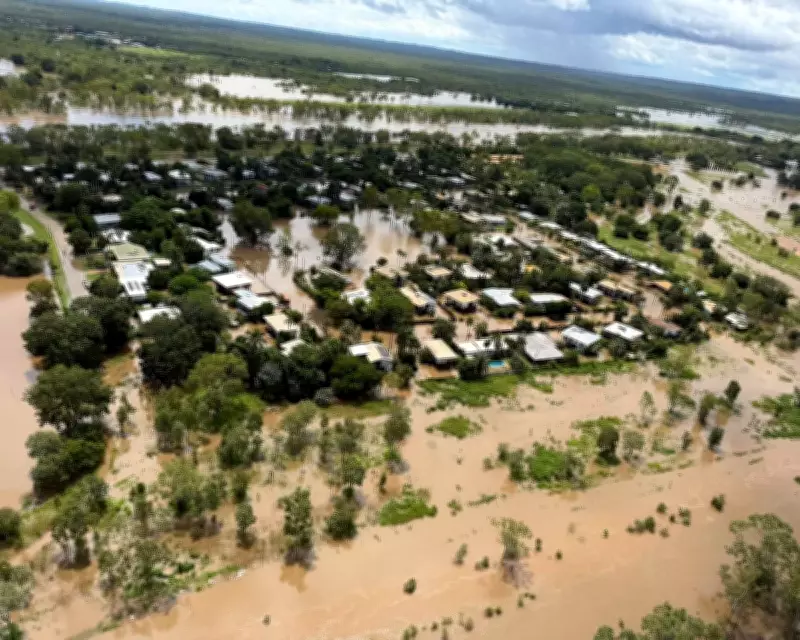
Katherine Endures Worst Flooding in Living Memory
The town of Katherine in the Northern Territory is experiencing its most devastating flooding in decades, prompting urgent safety advisories. Residents have been explicitly warned to avoid all floodwaters due to dual hazards: potential wastewater overflows and the presence of crocodiles.
Emergency services have been conducting airlift operations near the Daly River, where hundreds of residents were evacuated to Darwin over the weekend. The Bureau of Meteorology indicates that the Daly River is likely to remain above major flood levels for at least another week, prolonging the crisis.
Queensland Communities Submerged
In Queensland, the city of Bundaberg has suffered significant damage as the Burnett River overflowed its banks following a tropical low-pressure system. Hundreds of homes and businesses have been inundated, adding to the growing tally of flood-affected properties across northern Australia.
Maps illustrating river monitoring stations show more than 90 locations across New South Wales, the Northern Territory, and Queensland currently experiencing minor, moderate, or major flooding. The Bureau of Meteorology defines major flooding as events causing extensive inundation, likely isolation of towns and properties, and potential mass evacuations.
Historical Context and Climate Patterns
This flooding catastrophe follows Australia's wettest summer in nearly a decade, with national rainfall 32% above average for the 2025-26 season. Preliminary data suggests Darwin is experiencing its seventh wettest wet season on record, while Katherine is on track for its fifth wettest ever wet season.
The persistent rainfall and subsequent flooding highlight the increasing frequency of extreme weather events in the region. Emergency management agencies continue to monitor the situation closely, with recovery efforts expected to extend for weeks as communities assess the full extent of damage.