The Bureau of Meteorology has issued a stark warning as Severe Tropical Cyclone Maila charts a course toward the Queensland coastline, threatening to bring destructive winds and heavy rainfall to a region still reeling from the aftermath of Severe Tropical Cyclone Narelle less than three weeks ago. This new storm system, currently classified as a category 3 cyclone, is generating wind gusts of up to 185 kilometers per hour, with sustained winds reaching 130 km/hr, posing a significant risk to communities in far north Queensland.
Uncertain Path and Strength of Cyclone Maila
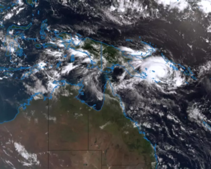
Meteorologists emphasize that forecasts for Cyclone Maila remain highly uncertain, with the storm's trajectory and intensity subject to change as it approaches land. As of Monday morning, the cyclone was circling the Solomon Sea, approximately 590 kilometers west of Honiara in the Solomon Islands. After days of erratic movement between Papua New Guinea and the Solomon Islands, it is expected to shift to a south-westerly direction midweek, heading directly toward the Queensland coast.
Helen Reid, a meteorologist with the Bureau of Meteorology, stated that the most probable scenario involves Maila making landfall at Cape York over the weekend. However, she cautioned that it is too early for definitive predictions, noting the storm could alter its path and veer away from the coast entirely. "It's still jury's out on this one, but it does look like it will be heading towards that peninsula coastline over the course of the weekend," Reid explained.

Potential Impact on Queensland Communities
If Cyclone Maila strikes, it could impact the same areas devastated by Severe Tropical Cyclone Narelle in March. Narelle, the season's strongest storm to date, made landfall in Cape York as a category 4 system on March 20, causing extensive damage to remote regions before crossing into the Northern Territory and Western Australia—a rare event not seen in 21 years. Reid highlighted that Maila might also swing south, threatening more populated centers like Cairns or Townsville, or it could miss the coast altogether.
The strength of Maila upon landfall remains unclear, but it is anticipated to intensify to category 4 before weakening back to category 3 in the coming days. Reid warned that it could cross the coast as a severe cyclone, with sustained wind speeds between 160 and 199 km/h. "We'll be keeping a very close eye on it, but at this stage, it may well still be another severe tropical cyclone through there," she added.
Warm Seas Fueling Cyclone Activity
Reid pointed out that the warm ocean temperatures that fueled Narelle's intensity are also contributing to Maila's development. "It hasn't had an opportunity to cool down. Narelle wasn't that long ago," she said. "There's still plenty of energy in that warm water." This environmental factor increases the potential for severe weather events, underscoring the urgency for residents to stay informed and prepared.
Historically, the last April cyclone to cross Queensland's coast was Severe Tropical Cyclone Ita in 2014, which made landfall near Cooktown in far north Queensland. As authorities monitor Maila's progress, communities are urged to heed official warnings and take necessary precautions to safeguard lives and property.