Satellite imagery provided a unique and powerful perspective on the defining events of 2025, enabling detailed coverage of natural disasters, conflicts, and major gatherings from orbit. The Sky News Data and Forensics team utilised this technology to deliver transparent, data-driven journalism throughout a tumultuous year.
A Year of Disaster and Conflict Seen from Above
The year began with devastation in California. From 7 to 31 January, wildfires, fuelled by strong winds and dry conditions, ravaged areas of Los Angeles and San Diego. Research published in the JAMA medical journal in August indicated the blazes killed at least 30 people directly and were responsible for an estimated 440 indirect deaths.
In February, the focus shifted to Sudan's civil war. Satellite images revealed the aftermath of an attack by Sudanese paramilitary Rapid Support Forces (RSF) fighters on the Zamzam refugee camp in North Darfur, showing burned buildings and stalls.

A major earthquake struck Myanmar on 28 March. The 7.7 magnitude tremor caused catastrophic damage, with United Nations estimates placing the death toll between 3,600 and 5,350. The disaster collapsed buildings nationwide, displacing around 200,000 people.
Political, Technological, and Humanitarian Crises
April saw a moment of global mourning captured from space, as thousands gathered in Vatican City on 26 April for the funeral of Pope Francis. The 88-year-old Argentinian pontiff, known for his progressive approach, had died five days earlier.
Technological tensions were visible in May, when synthetic-aperture radar (SAR) imagery showed clear banding effects from GPS jamming and electronic interference over the Russian enclave of Kaliningrad and the Baltic coast.
The war in Ukraine continued to leave its mark. Satellite photos from 4 June showed visible damage and cleanup operations at Russia's Belaya and Olenya airbases following successful Ukrainian drone strikes on 1 June.
A deepening humanitarian crisis was evident in Gaza by July. Imagery from 26 July showed hundreds of Palestinians crowding around aid trucks in southern Gaza as people struggled to access food. By August, famine was officially declared in Gaza City.
Protests, Storms, and Military Moves
In August, construction at a controversial Florida immigration detention centre dubbed 'Alligator Alcatraz' was temporarily halted by a US judge over environmental concerns, a decision visible in satellite monitoring.
September brought unrest to Nepal. On 9 September, the federal parliament building in Kathmandu was set alight during youth-led 'Gen Z' protests, which resulted in dozens of deaths. The damage to the palace grounds was clear in before-and-after satellite comparisons.
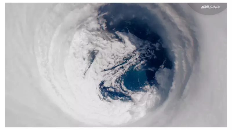
October witnessed the fury of Hurricane Melissa. This Category 5 storm, the worst to hit Jamaica on record, devastated the Caribbean on 28 October. The World Bank estimated physical damage at $8.8bn – a staggering 41% of Jamaica's 2024 GDP.
Geopolitical posturing followed in November, when the US deployed the advanced USS Gerald R Ford aircraft carrier to the Caribbean. The Trump administration labelled it a counter-drugs operation, but analysts widely viewed it as pressure on Venezuela's Nicolás Maduro.
The year closed with a more peaceful scene in December: striking nighttime satellite imagery captured Manhattan's festive glow on 4 December, a day after the iconic Rockefeller Center Christmas tree lighting.
The Sky News Data and Forensics team combines traditional reporting with advanced analysis of satellite images, social media, and open-source data to provide this unique form of multimedia storytelling, offering clarity on global events and demonstrating how modern journalism is done.