Satellite Imagery Uncovers Widespread Destruction in Iran Conflict
The Sky News Data & Forensics team has been meticulously monitoring the ongoing war in Iran through satellite imagery and verified online videos, providing critical insights into the ground reality. With an internet blackout in effect since the conflict began on 28 February 2026, satellite data has become a primary source for understanding the unfolding events. This analysis reveals significant damage to military installations and, alarmingly, civilian infrastructure.
Missile Bases Targeted to Curb Ballistic Capabilities
US and Israeli forces have focused on dismantling Iran's missile bases to degrade the regime's ability to launch ballistic missiles. Satellite images from 1 March show initial damage to a building at a base near the 'Ahmad Kazemi barracks' in Isfahan, with follow-up imagery from 3 March depicting the same structure completely flattened. This site, previously targeted in June, is among several hit, including an underground "missile city" near Kermanshah. Imagery from 4 March identifies at least 10 destroyed buildings and craters near tunnel entrances, suggesting attempts to collapse these fortified complexes. Iran's missile arsenal, including the long-range Sajjil capable of reaching up to 2,000km, poses a direct threat, making these bases key strategic targets. US Central Command reported an 86% drop in Iran's missile launches over four days, attributing this to the destruction of hundreds of air defence sites, missiles, and drones.
Naval Ports Suffer Severe Blows
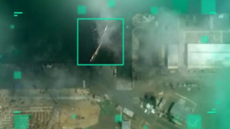
Naval facilities have also been heavily targeted to disrupt Iran's maritime operations. Satellite imagery from 4 March shows Konarak naval port in southern Iran with two destroyed buildings and a sunken ship. This port is strategically located near the Strait of Hormuz, a vital shipping route, and is used by the Iranian Revolutionary Guards for patrols and exercises. Additionally, the military harbour at Bandar Abbas, headquarters of the Iranian Navy, was struck, with imagery revealing the IRIS Makran, Iran's largest naval vessel, emitting smoke after a hit on 2 March. Recent images indicate major roof damage to a building at this site, further hampering naval capabilities.

Nuclear Facilities and Civilian Infrastructure Impacted
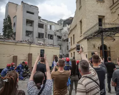
Strikes have extended to nuclear sites, with the Natanz Fuel Enrichment Plant in western Iran targeted. Imagery from 3 March shows three buildings destroyed, following earlier damage in June 2025 that reportedly severely affected centrifuges. The International Atomic Energy Agency confirmed entrance damage, highlighting ongoing tensions over Iran's nuclear programme. Tragically, civilian infrastructure has not been spared. A girls' school in Minab was hit on 28 February, with Iranian officials reporting over 150 fatalities. Satellite images from 4 March suggest multiple impact sites at the school, located near an IRGC base. In Tehran, Gandhi Hospital was damaged, as verified by videos showing a neighboring television tower in ruins. US and Israeli officials have denied deliberately targeting civilian sites, emphasizing their focus on military objectives.
The Sky News Data & Forensics team continues to leverage open-source intelligence, including satellite data and social media verification, to deliver transparent, data-driven journalism on this conflict, shedding light on the harsh realities of war in Iran.