A site long speculated to be the resting place of Noah's Ark has yielded new evidence that deepens the mystery. Researchers using ground-penetrating radar claim to have discovered a network of underground corridors and chambers beneath the Durupinar Formation in Turkey, a boat-shaped geological structure near Mount Ararat.
New Discoveries at Durupinar Formation
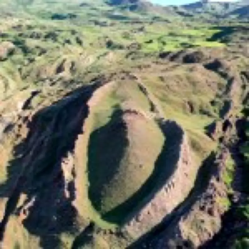
The Durupinar Formation, first identified in 1959 by Captain Ilhan Durupinar, has been at the center of Noah's Ark claims for decades. Its proximity to Mount Ararat, Turkey's highest peak, aligns with the biblical account that the ark came to rest on the 'mountains of Ararat' after the great flood. Now, a team of American researchers from Noah's Ark Scans has used ground-penetrating radar to identify what they describe as a network of tunnels below the surface.
Underground Corridors and Chambers
Andrew Jones, an independent researcher with Noah's Ark Scans, stated that these corridors lead to a hollow central chamber. He linked the find to the Bible's description of the ark, which mentions three internal levels for Noah, his family, and the animals. 'God told Noah to bring the animals in. And so these animals would have stayed there, plus Noah and his family,' Jones explained. 'What's interesting is that these voids are lining up below the ground — and they're not just random. These tunnels also follow a pattern.'

Further studies using special infrared technology have indicated the presence of a ship-shaped hull buried deep below the surface, according to a report by the Daily Mail. The team collected 88 samples from inside and outside the formation in 2024, with soil testing revealing high levels of potassium as well as decomposed lumber. 'We noticed that the grass growing within the boat-shaped formation is a different color compared to the area just outside it,' Jones added.
Previous Findings and Future Plans
In 2024, the researchers discovered angular structures up to 20 feet underground, which could represent rooms below a deck. William Crabtree, another researcher with Noah's Ark Scans, noted that a tunnel runs from the top of the formation towards the middle, large enough to walk through. Speaking to Patterns of Evidence, he said: 'The ultimate goal is not just soil test, or GPR scans, but to get inside the ship somehow. Core drilling, getting samples deep inside of it to where we see the substructure, these voids, put a camera in it. This is an opportunity coming up that possibly will allow us to do that next season.'
Context and Controversy
The findings come just months after pottery fragments were uncovered at the site during road construction, sparking further speculation. The fragments indicate human activity in the region between 5500 BC and 3000 BC, a timeframe some scholars associate with the biblical figure of Noah. While many argue that the Durupinar Formation is a naturally occurring geological feature, others believe it could point to the actual ark. The Bible's Book of Genesis describes the ark as 300 cubits long, 50 cubits wide, and 30 cubits high. The ongoing research continues to fuel debate among archaeologists, geologists, and biblical scholars alike.